
FREE ACCESS: Severe weather forecast for area through 7 a.m. Saturday
The National Weather Service has issued a severe storm warning for Greene and other counties through 7 a.m. Saturday.
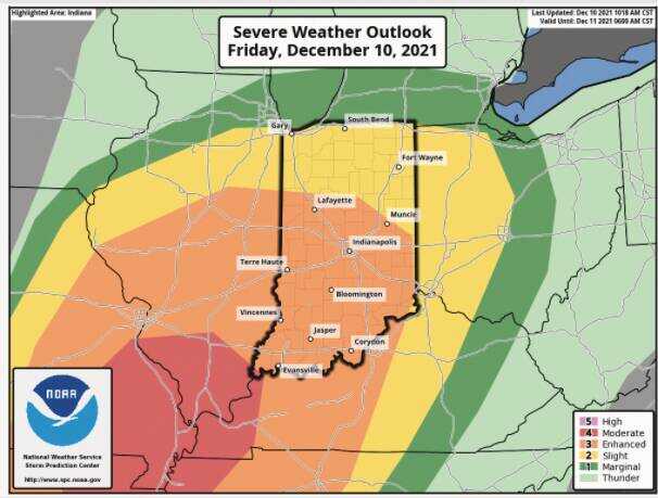
Counties under warning include Carroll, Warren, Tippecanoe, Clinton, Howard, Fountain, Montgomery, Boone, Tipton, Hamilton, Madison, Delaware, Randolph, Vermillion, Parke, Putnam, Hendricks, Marion, Hancock, Henry, Vigo, Clay, Owen, Morgan, Johnson, Shelby, Rush, Sullivan, Greene, Monroe, Brown, Bartholomew, Decatur, Knox, Daviess, Martin, Lawrence, Jackson and Jennings and include the cities of Delphi, Flora, Williamsport, West Lebanon, Lafayette, West Lafayette, Frankfort, Kokomo, Attica, Covington, Veedersburg, Crawfordsville, Lebanon, Zionsville, Tipton, Fishers, Carmel, Noblesville, Anderson, Muncie, Winchester, Union City, Farmland, Parker City, Clinton, Fairview Park, Rockville, Montezuma, Rosedale, Greencastle, Plainfield, Brownsburg, Danville, Indianapolis, Greenfield, New Castle, Terre Haute, Brazil, Spencer, Gosport, Martinsville, Mooresville, Greenwood, Franklin, Shelbyville, Rushville, Sullivan, Carlisle, Shelburn, Farmersburg, Linton, Bloomfield, Jasonville, Worthington, Bloomington, Nashville, Columbus, Greensburg, Vincennes, Washington, Loogootee, Shoals, Bedford, Mitchell, Seymour and North Vernon.
The official NWS warning is as follows:
358 AM EST Fri Dec 10 2021
This hazardous weather outlook is for central Indiana.
DAY ONE...Today and Tonight.
Patchy dense fog through 11 am.
Severe thunderstorms possible late this evening, and continue through
the overnight hours. Damaging winds will be the primary risk from
storms, but a few tornadoes and large hail will also be possible.
Brief heavy rainfall may produce localized flooding in some
locations as well.
DAYS TWO THROUGH SEVEN...Saturday through Thursday.
Scattered thunderstorms possibly severe will continue through early
Saturday, mainly for areas along and east of a Bloomington to
Rushville line.
Strong westerly wind gusts up to 45 mph are expected Saturday.